
Known as the Early Modern period, this time period is stuck right in between the Medieval period and Industrial age. It's mostly saw changes, such as the end of feudalism, the changes within city and urban economies, and the implication of pro-industrialism that would latter lead to the Industrial period. New markets to Asia would open up, and craft-guilds would lose their footing to technology and factories. It was a time of extraordinary change as Western Europe propelled itself into the Modern Era.
Analysis Essays
Timeline
Themes
Vocabulary
Analysis Essays
Timeline
Themes
Vocabulary
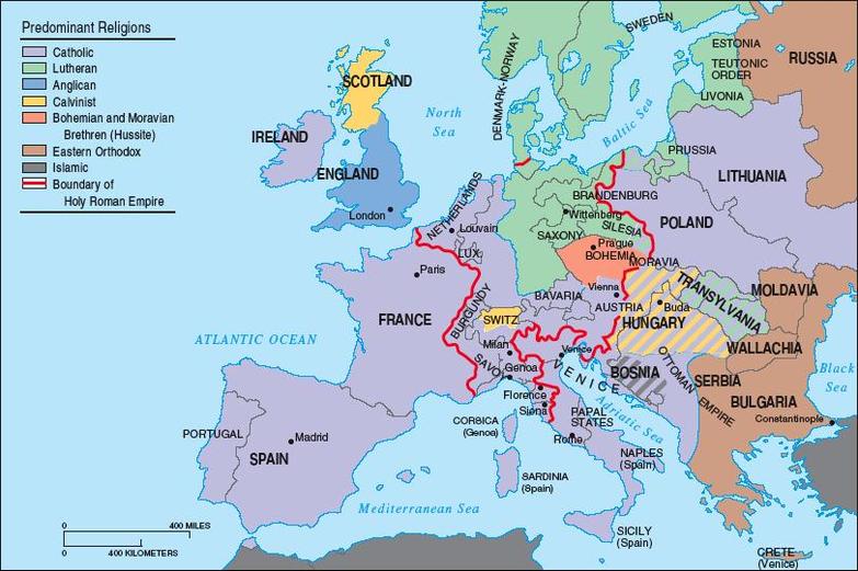
Europe during the Renaissance and Reformation
Source: http://www.myhistorylab.com
Map Analysis
1. The title of the map is Europe during the Renaissance and Reformation.
2. The map covers Europe.
3. The time period the map describes is 1450-1650.
4. Specific places marked on the map are large nation-states and important cities. They are marked because they were big powers in Europe during the time period.
5. N/A
6. All of Europe is shaded at least one color. The shading shows the different branches of Christianity the nation-state follows. The different colors are purple, green, blue, yellow, orange, brown, and grey. The colors signify Roman Catholic, Lutheran, Anglican, Calvinist, Bohemian and Moravian Brethren (Hussite), Eastern Orthodox, and Islamic respectively.
7. A symbol that is used is a red outline. It shows the boundary of the Holy Roman Empire and it is in central Europe.
8. The map shows the different nation-states during the Renaissance and Reformation in Europe. It also shows the branch of Christianity each of the nation-states followed.
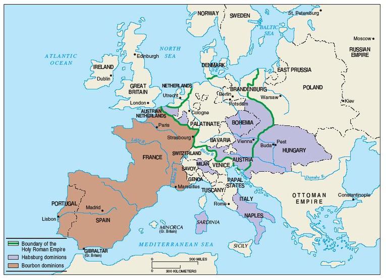
Europe under absolute monarchies, 1715
Source: http://www.myhistorylab.com/
Map Analysis
1. The title of the map is Europe Under Absolute Monarchies, 1715.
2. The map covers Europe.
3. The time period the map describes is the 1700s.
4. Important nation-states are shown on the map as well as the important cities. They are marked because they played an important part in the history of Europe during this time period.
5. N/A
6. France, Spain, Hungary, Austria, Naples, and Hungary are shaded. The shading signifies that they are under absolute monarchs. The different colors are red or purple. The Red signifies Bourbon dominions and the Purple signifies Habsburg dominions.
7. A green line is used to outline the boundary of the Holy Roman Empire. It is located in central Europe.
8. The map shows which nation-states were under absolute monarchs in 1715. It shows which of the absolute monarchs the nation-states were under as well.
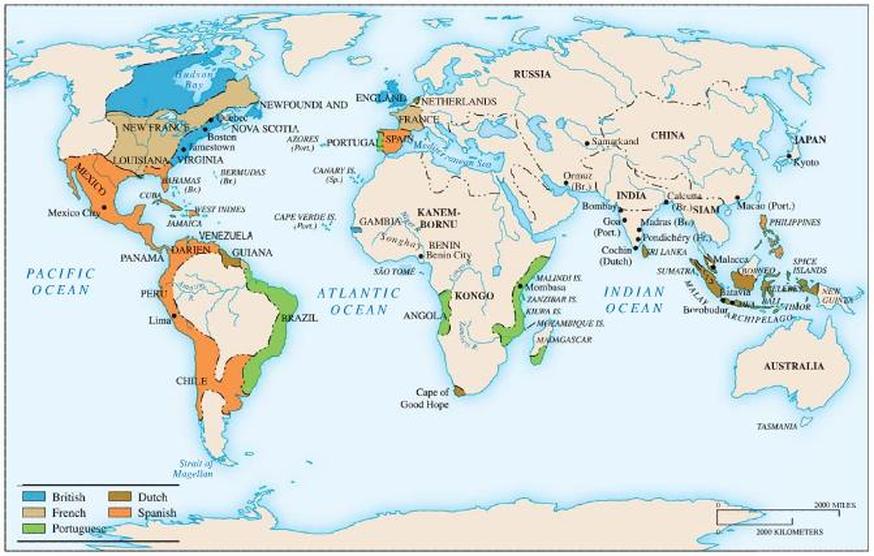
French, British, and Dutch Holdings c. 1700
Source: http://www.myhistorylab.com/
Map Analysis
1. The title of the map is French, British, and Dutch Holdings c. 1700.
2. The map covers the entire world.
3. The time period the map describes is 1700.
4. Specific places marked on the map are major port and trading towns. They are marked because they are why Europe wanted to go out and conquer the world in the first place.
5. N/A
6. Areas that are shaded are parts of North and South America, Western Europe, parts of Africa, and South East Asia. The shading signifies that they are held by a European power. The different colors are blue, tan green, brown, and orange. The colors show that the area is held by the British, French, Portuguese, Dutch, or Spanish respectively.
7. N/A
8. The map shows the areas of the world different European nation-states controlled. It shows that a large part of the Americas were controlled by either England, France, or Spain. The rest of the areas Europeans controlled are on the coasts for major trading ports.
